February 7, 2010
Bonanza meets Gilligan's Island
Now past the half way point on the south coast of Puerto Rico we have
arrived at the junction where TV shows from the 1960's meet. Yes, this
Gilligan's Island is named after the famous one. No signs of the
professor or Maryann, just three power boats rafted up and our pals on
Voyageur C. We are anchored between the island and the main land in
perfectly calm water. A small ferry runs from the San Jacinto dock out
to this mangrove island and yesterday it was packed with weekenders.
This is a great place to explore in the dingy. Access to the mangroves
and reef and small sand beaches is by boat only and the whole place
has a real frontier feel. I'm not sure if the small town here has
architectural covenants, but the small collection of houses are
amazing. Great design, beautiful lines, modern style and all are
completed - unlike most places in the Caribbean where rebar and
unfinished brickwork is pretty much standard.
February 5, 2010
Fish On! A big one too. We were heading towards Cayo Muertes…motoring
along minding our own business when suddenly ZING! That's the sound of
the line unreeling as the fish takes the bait. This guy is a real
fighter and continues to pull out the line, bending the rod over in
it's holder. Diving down the fish disappears we don't even get a
glimpse of what's on the end of the line. We've learned that it's best
not to rush the reeling in process, so we roll in the jib sail and
slow the boat down a bit. Half an hour later we still haven't seen
anything. We turn sideways so that Roy can reel in some of the line
and there, suddenly we see the fish surface. It looks a bit like a
barracuda, but it can't be because it's fighting so much. We continue
to pull on the line and slow down some until it finally surfaces not
far off our stern. Whoa, not only do we have a big fish, a shark is
holding on to it from behind. So much for the dragging method. Roy
reels in the fish as quickly as possible, but not before the shark
makes off with half of it. Bit clean in two our King Mackerel is still
impressive. Once filleted we have enough fish for at least six or
seven servings. So there Mr. Shark we both get dinner!


February 4, 2010
That's weird. I'm standing on the bow as we motor around the corner
from Puerto Patillas (which means sideburns in Spanish) to Cayos De
Barca (which means something not included in my Spanish flash card
kit), and a few hundred yards ahead I can see an sharp line marking
the end of the murky emerald green water we are currently plowing
through and a clear dark shade of blue that extends out to the
horizon. I take a picture for my collection of unusual water images
and look down as we cross over the color boarder. I've seen the water
change color at the confluence of a river and the sea before, but
nothing as abrupt and defined. A striking sight first thing this
morning.
The next weird, or rather unexpected thing happens a half hour later.
Still up at the bow I spot a catamaran coming along towards us on the
opposite tack. As it approaches I see that it's an older boat and
vaguely familiar. Out of nowhere the name pops into my mind. That's
Double Bells! How I have retained and been able to retrieve this
information is a complete mystery to me. Two years ago we had met this
couple and their dog in the Turks and Caicos. After chatting briefly
at a beach barbeque, we later crossed the Caicos banks in a group with
Double Bells and a whole gang of other boats. Double Bells ran into
trouble out on the choppy banks and since all cruisers are avid VHF
radio listeners, we heard their dramatic reports as they conferred
with their other sailing friends about their plight. The constant
pounding of the waves had taken a toll on Double Bells. They had
snapped a cable that helps hold up the mast and their wind generator
was flopping around half way up the back stay. Pretty major damage to
say the least. Roy and I had already bailed on the group and tucked
into the closest harbor of Long Cay to get out of the rough seas.
Double Bells came into view a few hours later. Rounding the corner
with their damaged rig clanking in the wind. They anchored nearby so
we went over to see what was what. They were putting on a brave face,
but the two of them were definitely rattled by the experience. We
wished them luck and that night headed out of South Caicos on our way
to Luperon on the North coast of the Dominican Republic. Forty-eight
hours later we were the ones rattled; seriously thinking about selling
the boat and going home! Another story for another time.
It doesn't look like anything else weird is going to happen today and
the scariest part so far has been the name of the cut in the reef we
passed through - Boca de Infierno. Now we are going to explore the
Cayos De Barca in our dingy and hopefully find a perfect swimming hole
behind the reef.
February 3, 2010
Waking up at Green Beach, Vieques offers all you would expect from a
deserted tropical island anchorage. Coconut palms and sea grape trees
line the beach and a small swell breaks on the coral reef just off
shore. Looking down into the clear green water off the bow I can see
the eel grass on the seabed waving in the current. Occasionally, some
small fish who is being chased by a bigger fish breaks the surface in
a frenzied bid for survival. Go! Get going! I urge them on, but I
always wonder why their jumping only takes them in a straight line.
Don't they know about dodging left or right?
After breakfast, which for me is always a granola bar. I still have a
stash of my favorite "Kashi" almond crunch ones onboard, Roy and I
agree to head out to the next stop west; Puerto Patillas. Protected by
a large reef, Patillas is a small fishing village along the south
coast of Puerto Rico. We did not stop here on the way through, so it
will be interesting to see something new. The weather looks the same
as it has the past few days…a little bit of rain and not too much
wind. Leaving Vieques behind, we pull out the jib and move along
smartly in 15-20 knots of breeze.
Of course now that we are going with the waves - following seas is the
term used to describe this situation. Following seas. I conger up
images like a friendly dog trotting behind his owner, or maybe a nice,
smooth rolling swell, lazily nudging the boat up and down. Well, today
started out with a well behaved 4-5 foot wind chop on the beam that
gradually built up to unruly 7 footers that began lumbering up from
behind us. You can feel the sheer weight and power of the water as the
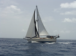
following seas shove the stern of Bonanza out of it's way. Our boat
weights about 23,000 pounds - that's equivalent to three small Honda
Civics.
At least we were being pushed towards the anchorage at Patillas. But
then I get to thinking. How are we going to get out of these waves and
into the anchorage? Somewhere along the line we'll have to turn hard
to starboard to slip behind the reef. I can't image putting these seas
on the beam of the boat while we motor for the shelter of the
anchorage. As I start mulling over this idea my heart rate begins to
go up. I ask Roy if he's getting concerned. "About what?" he replies.
Obviously it's just me, but I'm not liking what I see. We've just gone
through a set of waves that were getting into the 10-12 foot range. No
longer do they approach the boat at about eye level. Some of the
largest ones loom higher than the cockpit as we dip into the troughs
between them.
Roy points out that the boat is riding along in a balanced and
comfortable way. The waves look big, but the boat feels fine he says
and I have to admit the motion of the ocean isn't hectic at all. These
following seas are just following a little higher and steeper than I
would like. Now the wind is dropping as well. This limit's the amount
of forward power in our jib sail and slows us down considerably. With
8 miles left to go, we turn on the engine to give us more power and
speed and less time out in the waves for me angst about coming into
the harbour. The waves appear to be smoothing out. We have slipped
into a gap between an offshore ridge that comes up to about 40 feet
underwater and the shore. This reef acts to smooth out the waves a
fair amount. Much less menacing now the followers are back down to 6
feet. Back down into friendly dog range. Turns out that tucking in
behind the reef is no problem at all. We spot two other sailboats
inside the anchorage - a good sign when arriving somewhere for the
first time.
We don't have a great chart of this out of the way anchorage, so we
drop the hook just outside of were the two German flagged boats are
sitting. Stopping is good. From here behind the reef we can watch the
waves come roaring in and vanishing almost immediately as they break
on the rocks. We aren't exactly in calm water though; Bonanza is
rolling as the swell sneaking into the bay catches us broadside. Roy
launches the dingy and I grab the hand held depth sounder so we can
check out a route for going closer to shore. Depths get pretty skinny
as we head towards the swimming area, but with a just under five foot
draft we can easily make it to a spot out of the swell and into calmer
water. After re-anchoring we are ready for our Victory beer. Victory
beers follow all passages long or short - scary or boring - everyone
loves a cold one.
February 2, 2010
The Trip West
And now for something new: The Trip West. This is also supposed to be
the Trip Downwind. The significance of downwind sailing can probably
be appreciated only by a sailor, so if I go on about it throughout the
next pages please bear with me. The point is, downwind is easier. I
hope this proves true for us. The Trip South from where we bought this
boat in New Burn, North Carolina to Grenada was mostly an Upwind trip.
Sailing with the wind coming from the front side of the boat also
generally means sailing with the waves at the front side of the boat.
Waves from the front side are called "chop" for a reason. Chop, chop,
chop all the way through the Bahamas and most of the Caribbean island
chain. Chop, chop, chop can make you cry some days. The cruising
guides really mean it when they say don't try to go straight from St.
Kitts to Antigua. The day we did that the chop made weep. I'm really
done with the chop and really ready for the smooth, smooth, smoothness
of the following waves. More like a sliding, rocking motion. More like
you see in the sailing into the sunset retirement TV commercials. Yup,
that's what I'm dreaming of for this Trip West.
This is actually day two of the Trip. Yesterday we threw off the dock
lines at Puerto Del Ray marina in Fajardo, Puerto Rico. Bonanza spent
a few weeks relaxing in slip 1043 while Roy and I flew home to Calgary
to pack up our house. It sold over the Christmas holidays with a quick
possession date to meet, so we raced from St. Martin to Puerto Rico.
Marinas are great places to access marine suppliers, trades and
services. Great places to get caught up spending lots of cash and
discovering new things to fix. The fix list is never ending so at some
point you just have to get going again.
Motoring out of the bay directly into a rain squall reminded us that
the weather was once again our boss. Wind, rain, sea state…it's all
about the conditions when you are trying to travel by boat. We decided
on doing a short hop to a near-by anchorage on the west coast of
Vieques. Only a 15 mile jaunt from the marina, but a whole different
world. Now at anchor the boat is much more lively. The slight south
swell rocks us occasionally - nothing to lose sleep over. We watch the
sun slipping behind the island of Puerto Rico, streaming orange light
between passing rain clouds. We'll spend the next days moving along
the south coast retracing the last few known tracks on our Trip West.
We traveled this way two years ago on the Trip South. Heading into the
wind and seas, back then we did short motor hops along protected
pieces of the coast. This time will be different. Smooth, smooth,
smoothy…right?